

GIS integration of heterogeneous data for the archaeological topography of the ‘Acquedotto del Paradiso’, Syracuse
- Title
- GIS integration of heterogeneous data for the archaeological topography of the ‘Acquedotto del Paradiso’, Syracuse
- Creator(s)
- Giuseppe LuongoSee all items with this value
- Date
- 2024
- Is Part Of
-
 Archeologia e Calcolatori
- Volume
- 35
- Issue
- 2
- Pages
- 431-444
- Language
- eng
- Rights
- CC BY-NC-ND 4.0
- Abstract
- This study explores the GIS legacy data integration for a reassessment of the archaeological topography of Syracuse, with a focus on the Acquedotto del Paradiso. The research updates the understanding of Syracuse’s ancient waterscape by combining traditional archaeological methods with advanced digital technologies. Legacy data, historical maps, and recent fieldwork were systematically integrated into a GIS software, enhancing the spatial analysis and re-evaluation of the aqueduct’s route and construction phases. The study incorporated topographical bases, LiDAR point clouds, and autoptic analyses, revealing new insights into the aqueduct’s structural phases, including potential multi-phase construction and a double gallery system. The integration of these diverse datasets not only refined the known path of the aqueduct but also provided a detailed 2D and 3D visualization of it. This multidisciplinary approach emphasises the importance of combining traditional and modern techniques to improve the accuracy of archaeological topography, offering a more comprehensive understanding of ancient urban water supply systems in Syracuse.
- Zotero References Collection
- https://www.zotero.org/groups/5293298/bidiar/collections/MPTAETCW
- Cites
- Sicily under the Roman Empire: the archaeology of a Roman province, 36 BC-AD 535
- Digital technologies and the archaeological topography of Castellito (Sicily): the reconstruction of a Roman villa
- Italy’s Hidden Hillforts: A Large-Scale Lidar-Based Mapping of Samnium
- Opere pubbliche ed edifici per lo spettacolo nella Sicilia di età imperiale
- L’urbanistica di siracusa greca: nuovi dati, vecchi problemi
- The Aqueducts of Ancient Rome
- How to access ancient landscapes? Field survey and legacy data integration for research on Greek and Roman settlement patterns in Eastern Sicily
- Aqueducts and water supply in Greek and Roman Sicily
- Catania Antica. La carta archeologica.
- Antike Wasserkultur
- Die bewässerung von Syrakus
- Städte und Bauten der Westgriechen: Von der Kolonisationszeit bis zur Krise am Ende des 5. Jh. v.Chr.
- Il Porto Piccolo con l’arsenale dionigiano del Lakkios, forza strategica di Siracusa greca
- Le Antichità Della Sicilia Esposte Ed Illustrate
- Il complesso di viale Scala Greca e l’acquedotto del Paradiso a Siracusa
- Ricerche archeologiche nel siracusano
- Scoperte nelle due nuove arterie stradali
- Ipotesi di un acquedotto su arcate a sud dell’Anfiteatro di Siracusa
- De rebus siculis decades duae
- L'ipogeo di San Nicolò dei Cordari a Siracusa: fasi costruttive e funzione
- Siracusa. Rovine di un antico stabilimento idraulico in contrada Zappala'
- L'alimentation en eau de la colonie grecque de Syracuse
- Roma
- Topografia archeologica di Siracusa
- Antichi monumenti di Siracusa
- Osservazioni archeo-topografiche sull’insediamento d’altura nel territorio ibleo (Sicilia sud-orientale): il caso di Monte Casasia
- Paesaggi sacri della Sicilia orientale : riflessioni archeologiche e topografiche su aree di culto e viabilità
- Syracusan water networks in Antiquity
- Meccanismi di collasso nelle Latomie di Siracusa
- Studi e ricerche su l'anfiteatro di Siracusa
Export
- Media
-
 Diagram of the topographic data integration process
 -
 A) Orthophoto of Sicily. The red rectangle highlights the location of Syracuse on the East coast of the island; B) snapshoot of the QGIS software showing the Syracuse plateau area, illustrating the process of integrating and vectorizing the aqueduct path. In the background are Cavallari and Holm’s Tab. V, D. Mertens’ plan of Syracuse (Mertens 2006, 311, fig. 567), the CTR, and the orthophoto
 -
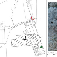
 A) Reconstruction of the Acquedotto del Paradiso route through the related UTs; B) cut section of the aqueduct visible along the eastern boundary of the Latomia del Paradiso (UT 149). The red circle highlights the votive panels (courtesy of Parco archeologico e paesaggistico di Siracusa, Eloro, Villa del Tellaro e Akrai)
 -
 At the top, a snapshot from Leica Cyclone 3DR showing the interpolated point cloud of the Syracuse plateau, with the route of the Acquedotto del Paradiso in white and the wells in blue. Below, the section obtained in AutoCAD after completing the process: a) Latomia del Paradiso; b) Roman amphitheater; c) Foro triangolare
 -
 New plan of the Piscina di San Nicolò ai Cordari and its surroundings. The red circle highlights the channel that fed the cistern. On the right, a detailed elevation view of that channel (courtesy of Parco archeologico e paesaggistico di Siracusa, Eloro, Villa del Tellaro e Akrai)
 -
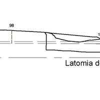 Section of the Acquedotto del Paradiso. Detail of the stretch passing through the Neapolis
 -
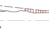 Section of the Acquedotto del Paradiso, detail. Hypothesis of an aqueduct stretch on arches. In red, Augustan arch and pillars
Position: 4624 (15 views)